SERVICES
Deep DC high accurate Vertical Electrical Sounding to investigate inexpensively basin layers and the quality of rocks
The resistivity depth sounding method can be applied for studying variations of resistivity with depth. The electrical resistivity of rock is a property which depends on lithology and fluid content. The ultimate objective of a VES is to obtain a true resistivity log similar to, for example, the induction log of a well at the locality, without actually drilling the well. However, because of inherent limitations, the resolution of the VES methods is not as high as that of the induction log. Nonetheless, the VES methods remain as the most inexpensive methods of subsurface exploration. They surpass the more expensive seismic method in one major respect. The seismic signal associated with a sandstone body would be the same whether its pores are saturated with hydrocarbons with fresh or with brackish water. On the other hand, its resistivity varies according to small changes in water salinity. This property together with the low cost make the VES methods very suitable for ground exploration and fluid content. And thanks to microprocessor electronics and software development it is now possible, when good control is available through wells which were drilled by means of modern drilling practices and logged by calibrated logging, to derive a unique interpretation from a VES provides leading to the true resistivities of the strata in absolute units
Complete seismic data conversion to SEG-Y format on DVD –RAM disks.
Technological advancements have converged to make DVD a preferred way to store seismic data compared to tapes or cartridges. Today with the DVD-RAM rewriteable disk seismic data can be located quickly and easily. With 9.4 gigabytes of total capacity for a $30 disk, 49 boxes containing 846 tapes can fit on one-third of a DVD-RAM disk. The corresponding DVD Drives have dropped in price to less than $300, so replication and write protection-even stored interpretations of the data-can be done effectively at low cost. We can convert from more than 1000 formats on tape to SEG-Y format (the most common seismic data storage format) on a DVD-RAM disk. Because The disks are hermetically sealed and the drive does not actually contact the medium , data are physically protected for 50 to 100 years. The data doesn’t need to be kept in a costly warehouse.
Planing, Modeling, Design and Analyzing of 2D/3D seismic data
We perform a detailed analysis of the target to be imaged and review existing data, maps and objectives with the client. We calculate the optimum parameters for each area and calibrate our calculations against observations from existing data. Our experience with modern instrumentation and methods enables us to optimize a design for image quality and cost effectiveness. We design the best survey whether the goal is: to define the limits of the field; to define the extent of a gas zone; for accurate well ties; for wavelet phase control; or to eliminate a foot print obscuring the attributes. We continually conduct research and study feedback and results of past designs in order to improve our product. We use the best software in the market to assist in program design and planning.

Organizing Seismic Design/QC/Processing Courses.
We have organized from 1998 numerous in house 3D Design/QC/seismic courses. In this context We are able to provide high quality training in the field of Oil and Gas. Exploration & Development at the best cost and to any location. We will bring the top Worldwide known professionals and experts to the benefit of the Client.
Client Representation for all type of situations and operations
We represent the Client in solving problems which arise during the implementation of the program and track costs as the job progresses. We report to the client and solicit his input as dictated by his desired level of involvement.
Seismic Contractor Selection and Bid Evaluation
We manage many field programs on behalf of some of our clients. We provide cost estimates, send out bid requests, reconcile the various bids which are received, contract permit agents, surveyors, drill pushes and other sub-trades as necessary to accomplish the client’s objectives.
OTHER AVAILABLE SERVICES
Gravity surveys
Seismic Field Quality Control
Seismic Interpretation
Complete Topography Surveying services
Electrical Imaging
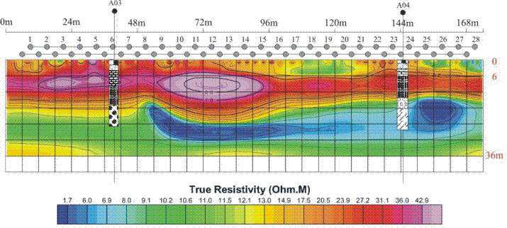
We also specialize in Electrical Imaging. With the new equipment we have, we can produce in one hour a section of the basement to a depth of 36 meters and a length of 200 meters showing the layers of the basement in color and with high definition. It should be noted that the equipment we have does not exist in many developed countries including the USA. No other geophysical equipment or technique can give a high definition SECTION so comparable. This imaging service has no equal in the profession and is of great value in mining, Environment studies, civil engineering, geothermal heat source exploration…

